WIND, WAVES, and a ROADWAY
Project draws on diverse disciplines to achieve sustainable solutions to shoreline erosion
If you were to walk the shoreline along Lazo Road, at the northeast edge of the Town of Comox, on British Columbia’s Vancouver Island, you might see surf scoters, cormorants and other birds on the water, or seals swimming by.
You might see people walking or jogging along the trail next to the road, enjoying the view east towards Texada Island and the mainland mountains. A bald eagle might fly by—there’s a nest nearby.
On the beach, lines of seaweed mark the tides’ reach. Piles of driftwood lie higher up the beach, where they were washed up during storms. Just above the driftwood, a narrow strip of exposed rocks follows the slope.
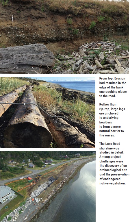
Amidst all these expected sights, you might spot something else—a cable looped tightly around a log. And, a few steps away, you might see another cable tying another log down. If you look closely, you might notice that the exposed rocks in the bank are a little too bare and, well, white. No lichens grow on them; little salt or grime encrusts them.
And, those dune grasses among the driftwood—they’ve just been planted. This stretch of shoreline along Lazo Road may look like it was shaped by wind, waves, and time, but engineers, geologists and biologists worked hard to create that impression.
SHORELINE PROTECTION; INFRASTRUCTURE AT RISK
“In 2011, the Town of Comox commissioned Wedler Engineering to undertake a study that would assess the condition of shoreline erosion along the 700-metre portion of Lazo Road within the town, and provide preliminary design, including cost estimates, for shoreline protection,” says Shelley Ashfield, P.Eng., Town of Comox municipal engineer. “Wedler concluded that approximately half of the foreshore in the study area had ongoing moderate to heavy erosion.”
The shoreline in this area historically consisted of active sand dunes. When Lazo Road was built many decades ago, it stopped the natural dune processes, but the sand remained.
Wedler’s study found that the sandy ground was eroding. With every winter storm, the edge of the bank encroached closer to the road. By 2011, the road’s shoulder started crumbling in places. Elsewhere, the bases of power poles were exposed. Informal footpaths from the roadside to the beach increased the erosion. A rip-rap wall protecting private property at the beach’s south end may have increased erosion on the beach.
“Over time,” says project engineer Andrew Gower, P.Eng., of Wedler Engineering, “the beach, the bank, and the road and other infrastructure next to it had seen considerable erosion— to the point where failure of the road and works was inevitable.” The design plan the company submitted in 2011 proposed a steep, long rip-rap wall like that already in place south of the project area. Although rip-rap is a relatively cost-effective solution for shoreline erosion, Gower had reservations: “Rip-rap walls are not the most environmentally or aesthetically pleasing approach.” And, he says, they cause problems. “They don’t sustain environmental values”—including ecological communities or spawning habitat for fish—“and they can amplify wave forces, scouring, and nearby erosion, which leads to safety and liability issues.”
However, by the time the Town of Comox obtained grant funding in 2014 for the work, the foreshore along the project area had changed significantly, and the plan had to be revisited anyways. This presented the town and project team with an opportunity to explore other solutions.
A MULTIDISCIPLINARY TEAM AND A CHALLENGING ENVIRONMENT
Town staff, Gower, a geotechnical engineer from Levelton (now WSP), and the project archaeologist, who also consulted with the local K’omoks First Nation, had all provided input during the project’s 2011 preliminary design phase. A key resulting recommendation was that a biologist and a wave-modelling and coastal-engineering specialist be added to the team for the project’s detailed design stage. In addition, work done for the preliminary phrase revealed an archaeological site within the project area. A local environmental group had also begun opposing the project.
“Because of the archaeological site, we needed an archaeologist,” Gower says. “Because we were dealing with coastal protection, we needed wave modelling and coastal engineering. Because we would be working in the foreshore, with fisheries and other environmental values of concern, we needed professional biologists.” Adding to the project’s growing complexity, the foreshore itself is dynamic and challenging.
“Everything is moving all the time,” Gower explains. “Tides and storm-generated waves constantly change the topography, so by the time we were ready to start construction on the beach, the initial 2011 foreshore survey data were no longer accurate, and we had to alter the project design to work with the new topography.”
The foreshore’s dynamic nature also meant adaptive management would be required during actual construction. Rysuk Geotechnical was brought on to supervise construction. Hazelwood Construction Services, the general contractor hired to complete the construction, needed to be willing to adjust daily to changing plans, as the foreshore environment shifted with the tides. “Because of the challenges of working in the foreshore,” Gower explains, “we needed expertise from multiple disciplines for the project to be successful. And, the client and the contractor needed to understand the fluid nature of the foreshore and the multidisciplinary requirements for working there.”
ASSESSMENTS AND SITE-SPECIFIC APPROACHES
Gower says that “the main goal of the project was to protect the road from erosion. At the same time, we wanted to look at a more balanced approach and apply best practices and sustainable solutions.” A coastal-engineering assessment was key to developing a detailed project design. An assessment examines a site’s environmental conditions—the wind, the waves, the ocean levels, the causes of the erosion, and the site’s geomorphology. But, every stretch of coastline is unique. Its underlying geological processes vary, sometimes every few metres. Wind and waves affect each section of shoreline differently, and what’s going on in one area can impact other areas in different ways. To gain an accurate, finer-resolution picture of shoreline dynamics in the project area, the project team divided the stretch of Lazo Road shoreline into seven sections, based on depth and state of foreshore and backshore. The sections were then studied in detail.
Northwest Hydraulic Consultants(NHC) examined each section’s coastal processes and assessed how waves, wind, storm surge and tidal conditions interacted. In the report to Wedler Engineering, NHC’s David McLean, P.Eng., noted that the wave analysis indicated that the intensity of wave attack, which contributes significantly to erosion, varied significantly with elevation. Based on this, he wrote, “the type of erosion protection measures that are appropriate also depend on their location and elevation range.”
The biologists studied the beach sediments and identified potential spawning habitat for herring, sand lance and other important forage fish. “We also inventoried the shoreline’s ecological communities of vegetation,” says Warren Fleenor, RPBio, of Current Environmental, the firm hired to perform the environmental assessment. “We identifiedrare communities and used those to help inform the revised project design.” Of particular concern was the dune wildrye–beach pea community, which is redlisted (endangered or threatened) in BC. The biologists noted remnants of the community in the high intertidal and splash zones of the shoreline throughout the project area.
Having biologists on the team was essential for determining the best approaches for erosion protection that considered environmental values as well as infrastructure values. “They tell me what’s important biologically,” McLean says, “and I tell them what the driving forces are and what we might do, and together we come up with a solution that is most appropriate for that environment.” For example, the shoreline’s dunes form a setting that is both geologically and environmentally unique, with fine sand deposits. McLean says “the challenge was how to go about building shoreline protection in an environment like that, compared to on a conventional beach or on a big rocky shoreline, and not permanently change that environment.” The detailed assessments meant that the project team was able to move from a design that relied on a one-size-fits-all approach for erosion protection along the 700-metre stretch of shoreline to a softer approach that integrated lower-impact riprap installation with anchored driftwood and native vegetation.
For areas where elevation and depth of the foreshore and backshore allowed, the design team recommended, for example, burying the toe of the protection work’s rip-rap backbone beneath beach sediments and decreasing the angle of the shoreline slope to diffuse wave force, prevent erosion, and protect forage fish–spawning areas. They suggested using large logs on the surface instead of rip-rap, and anchoring the wood to the underlying boulders to form a more natural barrier to the waves. They also recommended salvaging driftwood, beach sands and native plants from foreshore areas that would be excavated, and replacing and replanting them after construction to mimic original conditions.
In one location along the road, they advised leaving the shoreline be. The dune habitat there was well established, and the foreshore and backshore were stable and sheltered from the weather. The dune itself protects the road. However, in places where the road lies close to the shoreline edge and is exposed and low-lying, options were limited. A wall of rip-rap now protects that segment of road. “It becomes a hard-engineering solution,” McLean says. “There’s really no other option. But in other places, we had more flexibility, and we tried to find where there were opportunities to do as much soft engineering as possible.” The archaeological site also presented challenges. In the end, the project archaeologist and the contractor came up with a solution that maintained the archaeological site’s integrity while allowing the project to proceed.
“We worked around and on top of the shell middens,” Gower says. “Because we left the site undisturbed, we didn’t have any archaeological finds to deal with, and all that material is still there, untouched.” Shelley Ashfield, Town of Comox municipal engineer, says that, while a number of considerations led to the town choosing the new approach for the project, “the results and completion of the detailed coastal engineering work conducted by Northwest Hydraulic Consultants” was the biggest reason the town changed the project design.
SUSTAINABLE SOLUTIONS AND PUBLIC RESPONSE
The change in approach offered the Town of Comox sustainable solutions. The design team worked with town officials to explore options, review similar projects, and justify to the public the solutions that were proposed and built. At one point, when resistance from local residents and environmental groups halted work on the project for a few days, the town arranged for the environment group, Project Watershed, to tour the project site with the general contractor and members of the design team.
In the letter the organization later sent to town staff, Project Watershed’s Technical Director Dan Bowen recommended changes to the public-engagement process and suggested environmental monitoring continue after the project was finished. He also wrote, “We are satisfied with the overall project design and the rationale for the use of rip-rap and the way it is being installed to reduce wave energy as much as possible.” Ashfield fully credits the collaborative multidisciplinary team. “The success of the project is due to the design team, which included expertise in environmental engineering, coastal engineering, geotechnical engineering, and civil engineering, as well as coastal biology.” So, when you next walk along Comox’s Lazo Road waterfront, take a moment to admire the jumbled arrangement of anchored logs, the replanted dune grasses, and the narrow strip of exposed rip-rap halfway down the slope.
The soft engineering you see protects the road and the trail you walk on. It addresses future sea-level rise. It preserves key environmental and archaeological values. It also means you and others will be able to walk safely along Lazo Road for many years to come.
by Alex B. Leblanc
Source: January/February issue of Innovation magazine, published by the association for Engineers and Geoscientists British Columbia